In this post we are going to learn about use of google maps marker clustering when we requires to show a large number of data points on the Google maps.
For this we are using the google maps marker Clustering Utility class.
![]()
in the above image The number on a cluster indicates how many markers it contains. Once we zoom onto cluster location we’ll able see the markers. We can also show Current Location with Zoom Options
Let's get Started
Step 1: Create Android application
Step 2: Setup Google Maps API to application.
Check the link to Setup Google Maps API
Step 3: Add dependencies to gradle file
implementation 'com.google.maps.android:android-maps-utils:1.0.2'
implementation 'com.google.android.gms:play-services-maps:17.0.0'
|
Step 4:
Now need to do marker clustering done on Google Maps. The simplest way to show the cluster, first, we need to implement ClusterItem on our model class. Let’s create a simple User class that implements ClusterItem.
package com.rrtutors.googlemapcluster

import com.google.android.gms.maps.model.LatLng
import com.google.maps.android.clustering.ClusterItem

class User constructor(username: String,latLng: LatLng,url :String): ClusterItem {

    var username=username;
    var url=url;
    var latLng=latLng;
    override fun getSnippet(): String {

        return "";
    }

    override fun getTitle(): String {

        return username;
    }

    override fun getPosition(): LatLng {
        return latLng;

    }


}
|
Step 5: Update MainActivity
package com.rrtutors.googlemapcluster

import androidx.appcompat.app.AppCompatActivity
import android.os.Bundle
import com.google.android.gms.maps.CameraUpdateFactory
import com.google.android.gms.maps.SupportMapFragment
import com.google.maps.android.clustering.ClusterManager
import com.google.android.gms.maps.GoogleMap
import com.google.android.gms.maps.model.LatLng
import java.util.*


class MainActivity : AppCompatActivity() {

    override fun onCreate(savedInstanceState: Bundle?) {
        super.onCreate(savedInstanceState)
        setContentView(R.layout.activity_main)

        val supportMapFragment = supportFragmentManager.findFragmentById(R.id.map) as SupportMapFragment?  // 1
        supportMapFragment!!.getMapAsync { googleMap ->
            // 2
            setUpClusterManager(googleMap)
        }


    }

    private fun setUpClusterManager(googleMap: GoogleMap) {
        val clusterManager = ClusterManager<User>(applicationContext , googleMap)  // 3
        googleMap.setOnCameraIdleListener(clusterManager)
        val items = getItems()

        googleMap.moveCamera(CameraUpdateFactory.newLatLngZoom(items?.toList()?.get(6)?.latLng, 14.0f));
        clusterManager.addItems(items)  // 4
        clusterManager.cluster()  // 5
    }

    private fun getItems(): MutableCollection<User>? {
        return Arrays.asList(
            User("Location1", LatLng(-31.563910, 147.154312), "https://www.rrtutors.com"),
            User("Location2", LatLng(-33.718234, 150.363181), "https://www.rrtutors.com"),
            User("Location3", LatLng(-33.727111, 150.371124), "https://www.rrtutors.com"),
            User("Location4", LatLng(-33.848588, 151.209834), "https://www.rrtutors.com"),
            User("Location5", LatLng(-33.851702, 151.216968), "https://www.rrtutors.com"),
            User("Location6", LatLng(-34.671264, 150.863657), "https://www.rrtutors.com"),
            User("Location7", LatLng(-35.304724, 148.662905), "https://www.rrtutors.com"),
            User("Location8", LatLng(-36.817685, 175.699196), "https://www.rrtutors.com"),
            User("Location9", LatLng(-36.828611, 175.790222), "https://www.rrtutors.com"),
            User("Location10", LatLng(-37.750000, 145.116667), "https://www.rrtutors.com"),
            User("Location11", LatLng(-37.759859, 145.128708), "https://www.rrtutors.com"),
            User("Location12", LatLng(-37.765015, 145.133858), "https://www.rrtutors.com"),
            User("Location13", LatLng(-37.770104, 145.143299), "https://www.rrtutors.com"),
            User("Location14", LatLng(-37.773700, 145.145187), "https://www.rrtutors.com"),
            User("Location15", LatLng(-37.774785, 145.137978), "https://www.rrtutors.com"),
            User("Location16", LatLng(-37.819616, 144.968119), "https://www.rrtutors.com"),
            User("Location17", LatLng(-38.330766, 144.695692), "https://www.rrtutors.com"),
            User("Location18", LatLng(-39.927193, 175.053218), "https://www.rrtutors.com"),
            User("Location19", LatLng(-41.330162, 174.865694), "https://www.rrtutors.com"),
            User("Location20", LatLng(-42.734358, 147.439506), "https://www.rrtutors.com"),
            User("Location21", LatLng(-42.734358, 147.501315), "https://www.rrtutors.com"),
            User("Location22", LatLng(-42.735258, 147.438000), "https://www.rrtutors.com"),
            User("Location23", LatLng(-43.999792, 170.463352), "https://www.rrtutors.com")
        )
    }
}
|
Explanation for above code
That's it, it will show the Markers with clustering when ZoomOut the marker.
Custom Icon inside Marker
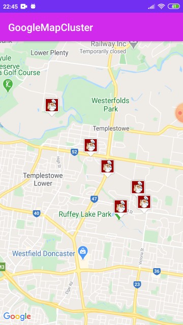
Now let’s say we need to change the default marker icon which shows inside the Cluster Marker with custom marker. For that, we need to create a new ClusterRenderer with to extend the DefaultClusterRenderer class.
package com.rrtutors.googlemapcluster

import android.content.Context
import android.graphics.Bitmap
import android.widget.ImageView
import com.google.android.gms.maps.GoogleMap
import com.google.android.gms.maps.model.BitmapDescriptorFactory
import com.google.android.gms.maps.model.MarkerOptions
import com.google.maps.android.clustering.ClusterManager
import com.google.maps.android.clustering.view.DefaultClusterRenderer
import com.google.maps.android.ui.IconGenerator
import android.view.ViewGroup

class MarkerClusterRenderer(context:Context, map:GoogleMap, clusterManager:ClusterManager<User>?):
    DefaultClusterRenderer<User>(context, map, clusterManager) {
    private val MARKER_DIMENSION = 48  // 2
    private var iconGenerator: IconGenerator? = null
    private var markerImageView: ImageView? = null
    init {
        iconGenerator = IconGenerator(context)  // 3
        markerImageView = ImageView(context)
        markerImageView!!.setLayoutParams(ViewGroup.LayoutParams(MARKER_DIMENSION, MARKER_DIMENSION))
        markerImageView!!.setBackgroundColor(getColor(R.color.colorPrimary))
        iconGenerator!!.setContentView(markerImageView)
    }

    override fun onBeforeClusterItemRendered(item: User?, markerOptions: MarkerOptions?) {
        super.onBeforeClusterItemRendered(item, markerOptions)

        markerImageView?.setImageResource(R.drawable.img_chef);  // 6
       var icon = iconGenerator?.makeIcon();  // 7
        markerOptions?.icon(BitmapDescriptorFactory.fromBitmap(icon));  // 8
        markerOptions?.title(item?.getTitle());
    }


}
|
In the above code we added Marker options to set google maps marker icon and google maps marker title
Now call this MarkerClusterRenderer after creating the object of
val clusterManager = ClusterManager<User>(applicationContext , googleMap)
private fun setUpClusterManager(googleMap: GoogleMap) {
    val clusterManager = ClusterManager<User>(applicationContext , googleMap)  // 3
    clusterManager.renderer = MarkerClusterRenderer(this, googleMap, clusterManager)

    googleMap.setOnCameraIdleListener(clusterManager)
    val items = getItems()

    googleMap.moveCamera(CameraUpdateFactory.newLatLngZoom(items?.toList()?.get(6)?.latLng, 14.0f));
    clusterManager.addItems(items)  // 4
    clusterManager.cluster()  // 5
}
|
Access Views inside activity by View Binding Technique instead of findViewById() property, which will reduce the code length
The output will become like below

|
Article Contributed By :
|
|

|
|
|
3924 Views |
|