Jetpack Compose - How do i draw Path(poly lines) between two locations On Google Maps
Draw Path between two Locations. To add Poly lines to the Google Maps we will use map.addPolyline() method. In the previous tutorial we cover how to add Markers to the Google Maps with Jetpack compose.
In this Jetpack compose Google Maps tutorial we will create a Google Maps and Draw Path between two Locations. To add Poly lines to the Google Maps we will use map.addPolyline() method. In the previous tutorial we cover how to add Markers to the Google Maps with Jetpack compose.
sample to code to add Ploy lines to maps
map.addPolyline( PolylineOptions().add( pickUp, LatLng(17.711845, 76.006210), //Root of Solapur LatLng(17.839834, 76.718450), //Root of Osmanabad destination ) |
Let's get started
Step 1: Create Jetpack Compose project with Andorid studio
Step 2: Add required dependencies in build.gradle file
Read previous example How to setup and Load Google Maps with Jetpack Compose
Step 3: Load Google Maps
AndroidView(
    {mapView}
) { mapView ->
    CoroutineScope(Dispatchers.Main).launch {


            mapView.getMapAsync {
} } |
Step 4: Create Polylines and add it to Google Maps
To Add poly lines between two location we need locations latlng, then add these lanlngs to PolylineOptions().
map.addPolyline( PolylineOptions().add( pickUp, LatLng(17.711845, 76.006210), //Root of Solapur LatLng(17.839834, 76.718450), //Root of Osmanabad destination ) ) |
To set the color for the Path between tow location by add color property to the PolylineOptions
map.addPolyline( PolylineOptions().add( pickUp, LatLng(17.711845, 76.006210), //Root of Solapur LatLng(17.839834, 76.718450), //Root of Osmanabad destination ) ).color = R.color.red |
Step 5: Run application, you can find the path between two given locations on the Maps.
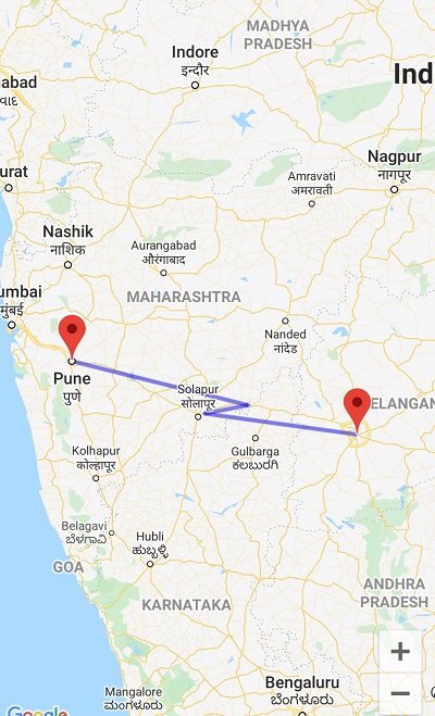 |
Complete code for Draw poly lines on the maps between two location
package com.rrtutors.compose_maps import android.os.Bundle import androidx.activity.ComponentActivity import androidx.activity.compose.setContent import androidx.compose.foundation.background import androidx.compose.foundation.layout.Column import androidx.compose.foundation.layout.fillMaxSize import androidx.compose.material.MaterialTheme import androidx.compose.material.Surface import androidx.compose.runtime.Composable import androidx.compose.runtime.DisposableEffect import androidx.compose.runtime.remember import androidx.compose.ui.Modifier import androidx.compose.ui.graphics.Color import androidx.compose.ui.platform.LocalContext import androidx.compose.ui.platform.LocalLifecycleOwner import androidx.compose.ui.viewinterop.AndroidView import androidx.lifecycle.Lifecycle import androidx.lifecycle.LifecycleEventObserver import com.google.android.libraries.maps.CameraUpdateFactory import com.google.android.libraries.maps.MapView import com.google.android.libraries.maps.model.LatLng import com.google.android.libraries.maps.model.MarkerOptions import com.google.android.libraries.maps.model.PolylineOptions import com.google.maps.android.ktx.awaitMap import com.rrtutors.compose_maps.ui.theme.ComposeMapsTheme import kotlinx.coroutines.CoroutineScope import kotlinx.coroutines.Dispatchers import kotlinx.coroutines.launch class MainActivity : ComponentActivity() { override fun onCreate(savedInstanceState: Bundle?) { super.onCreate(savedInstanceState) setContent { ComposeMapsTheme { // A surface container using the 'background' color from the theme Surface(color = MaterialTheme.colors.background) { GoogleMaps() } } } } } @Composable fun GoogleMaps() { val mapView = rememberMapViewWithLifeCycle() Column( modifier = Modifier .fillMaxSize() .background(Color.White) ) { AndroidView( {mapView} ) { mapView -> CoroutineScope(Dispatchers.Main).launch { val map = mapView.awaitMap() map.uiSettings.isZoomControlsEnabled = true val pickUp = LatLng(17.385, 78.4867) //Hyderabad val destination = LatLng(18.5204, 73.8567) //Pune map.moveCamera(CameraUpdateFactory.newLatLngZoom(destination, 8f)) val markerOptions = MarkerOptions() .title("Hyderabad") .position(pickUp) map.addMarker(markerOptions) val markerOptionsDestination = MarkerOptions() .title("Pune") .position(destination) map.addMarker(markerOptionsDestination) map.addPolyline( PolylineOptions().add( pickUp, LatLng(17.711845, 76.006210), //Root of Solapur LatLng(17.839834, 76.718450), //Root of Osmanabad destination ) ).color = R.color.red //Polyline color } } } } @Composable fun rememberMapViewWithLifeCycle(): MapView { val context = LocalContext.current val mapView = remember { MapView(context).apply { id = com.google.maps.android.ktx.R.id.map_frame } } val lifeCycleObserver = rememberMapLifecycleObserver(mapView) val lifeCycle = LocalLifecycleOwner.current.lifecycle DisposableEffect(lifeCycle) { lifeCycle.addObserver(lifeCycleObserver) onDispose { lifeCycle.removeObserver(lifeCycleObserver) } } return mapView } @Composable fun rememberMapLifecycleObserver(mapView: MapView): LifecycleEventObserver = remember(mapView) { LifecycleEventObserver { _, event -> when(event) { Lifecycle.Event.ON_CREATE -> mapView.onCreate(Bundle()) Lifecycle.Event.ON_START -> mapView.onStart() Lifecycle.Event.ON_RESUME -> mapView.onResume() Lifecycle.Event.ON_PAUSE -> mapView.onPause() Lifecycle.Event.ON_STOP -> mapView.onStop() Lifecycle.Event.ON_DESTROY -> mapView.onDestroy() else -> throw IllegalStateException() } } } |
Conclusion: We have done with draw route between two locations using Google Maps